 Rank: Advanced Member
Groups: Member
Joined: 01/08/2010(UTC)
Posts: 335
Location: uk
|
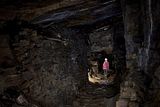
Workers at Craken Quarry
I am not sure if this represents the whole workforce at the time or not, but looking at other photographs I have of different Quarries there are more people on this picture than others. shallcross attached the following image(s): |
Shallcross |
|
|
|
|
|
 Rank: Advanced Member
Groups: Member
Joined: 03/09/2010(UTC)
Posts: 170
Location: buggy
Thanks: 3 times
Was thanked: 11 time(s) in 9 post(s)
|
Green_Gentleman wrote:
Ordonance Survey has this feature as a 'lake' so it could just be dried reeds we are looking at give the image looks like it was taken in mid-summer or spring at the earliest. Conveniently however there is a path which crosses near the feature, aswell as an airshaft to it's left so I may go take a wander when the weather warms up a little more. I would assume the 'trial holes' close to the summit of Chinley Churn are associated air shafts in relation to the mines which have now collapsed?
Great post!...love that info....But as the consensus is a more recent industrial relic im inclined to go that way ....as does look more like something for water catctchment.
I have been lucky enuff to fly over the Australian outback and you see similar looking marks that are exacly that....concrete water catchment 'things' , i did notice on one map it had a 'Sheep Fold' mentioned...in the area just behind the working quarry
It does a bit to precise for a barrow.......
But hey I never knew about Taro Trin - the "Bull of Conflict".....I like the romance of that ....so will investigate further
Anyone got a Geophiz machine?...
|
|
|
|
|
|
Rank: Advanced Member
Groups: Member
Joined: 03/09/2010(UTC)
Posts: 170
Location: buggy
Thanks: 3 times
Was thanked: 11 time(s) in 9 post(s)
|
Mr Shalcross....any dates on these pics?...
thanks
|
|
|
|
|
|
Rank: Advanced Member
Groups: Member
Joined: 03/09/2010(UTC)
Posts: 170
Location: buggy
Thanks: 3 times
Was thanked: 11 time(s) in 9 post(s)
|
Im not trying to convince myself....
but after looking at google veiws of arbour low, and the bull ring.....there are striking resemblenses....
I just noticed that nearby there are more circular mounds....very siminlar to barrow sites next ro similar peak district ring sites....just on the left of my snip near the road
Edited by user 13 February 2012 13:39:29(UTC)
| Reason: Not specified moogie attached the following image(s):
|
|
|
|
|
|
 Rank: Advanced Member
Groups: Administration, Member
Joined: 06/09/2010(UTC)
Posts: 94
Location: Around and about
Thanks: 4 times
Was thanked: 5 time(s) in 5 post(s)
|
moogie wrote:
Im not trying to convince myself....
but after looking at google veiws of arbour low, and the bull ring.....there are striking resemblenses....
I think you need to get out there to have a look on the ground. It still looks as if a stream is emerging from the mystery circle. I suspect that coal mining remains might well account for some of the other circular features.
|
|
|
|
|
|
Rank: Advanced Member
Groups: Member
Joined: 03/09/2010(UTC)
Posts: 170
Location: buggy
Thanks: 3 times
Was thanked: 11 time(s) in 9 post(s)
|
tarboat wrote:
moogie wrote:
Im not trying to convince myself....
but after looking at google veiws of arbour low, and the bull ring.....there are striking resemblenses....
I think you need to get out there to have a look on the ground. It still looks as if a stream is emerging from the mystery circle. I suspect that coal mining remains might well account for some of the other circular features.
I aim too, now the snow has cleared.......i will take some ground level shots and post them up....
|
|
|
|
|
|
 Rank: Advanced Member
Groups: Member
Joined: 19/01/2011(UTC)
Posts: 135
Location: Whaley Bridge
|
Took a hike up to this 'mound' today seeing the weather was nice (for a time.) I had a quick scour of the field and followed the fence-line, but it's looking more like a water 'holding' feature, most likely created by farmers gone to exploit the run-off from the Chinley Churn summit and to give the cattle some freshwater.
Very boggy and marshy downstream of this, which also leads me to think that foundation base of this feature must have been breached (naturally or intentionally) some time in the past. Had it been a mound or Stone-Circle example It's placement on the hillside doesn't match up with it's intended design, definitely no orientation or discernable features.
I still got a good hike out of it though.
|
|
|
|
|
|
Rank: Newbie
Groups: Member
Joined: 18/04/2012(UTC)
Posts: 4
Location: UK
|
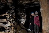
Great picture Shalcross of the winding wheel. Is the second picture definitely at Cracken Edge?
With regard to the hanging death in the Quarry, I've had a fairly good mooch round there, and there are 5 which are possible to enter without too much risk.
I've also recently seen some pictures of another mine that I've not been in yet.
What is obvious up there, though is that there are a number of entrances which have been long sealed.
I've some pictures of inside the quarries if anyone is interested.
Rich
|
|
|
|
|
|
Rank: Advanced Member
Groups: Member
Joined: 03/09/2010(UTC)
Posts: 170
Location: buggy
Thanks: 3 times
Was thanked: 11 time(s) in 9 post(s)
|
yes rich ...i would love to see them!...
|
|
|
|
|
|
Rank: Newbie
Groups: Member
Joined: 24/04/2012(UTC)
Posts: 1
|
John Frith (of Bank Hall, Chapel-en-le-Frith) owned slate quarries at Cracken Edge in 1837. On his death these passed to his natural son Nathan Woodroofe, schoolmaster of Bamford
|
|
|
|
|
|
Rank: Advanced Member
Groups: Member
Joined: 01/08/2010(UTC)
Posts: 335
Location: uk
|
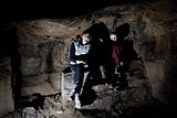
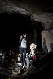
Hi Rich
I think that they are both of Craken Quarry but only because I aquired them both together if you know different then please let us know I would be interested in your comments. |
Shallcross |
|
|
|
|
|
Rank: Newbie
Groups: Member
Joined: 18/04/2012(UTC)
Posts: 4
Location: UK
|
shallcross wrote:
Hi Rich
I think that they are both of Craken Quarry but only because I aquired them both together if you know different then please let us know I would be interested in your comments.
My query was because a) The rock behind them looks much less compact than the Cracken Edge quarry faces that show today, and b) none of the faces match up in both pictures.
Here's some pics for you.
    Edited by user 02 May 2012 09:43:45(UTC)
| Reason: Not specified
|
|
|
|
|
|
Rank: Advanced Member
Groups: Administration, Member
Joined: 06/09/2010(UTC)
Posts: 94
Location: Around and about
Thanks: 4 times
Was thanked: 5 time(s) in 5 post(s)
|
I have been led to believe that the book on the history of Chinley has a small section about Cracken Edge quarries which mentions the incline and another tramroad. Does anyone have a copy of this book and is prepared to extract the relevant information if it is only a paragraph or two? I don't know if it is in print or who the author is.
|
|
|
|
|
|
Rank: Advanced Member
Groups: Member
Joined: 10/07/2009(UTC) Posts: 794  Location: furness vale Thanks: 3 times
|
Crichton Porteous writing in The Manchester Guardian of 27th September 1951 gives this account of Cracken Edge Quarry."Stone for floors and roofs came out of special quarries. On Cracken Egde, over Chinley, the stone was got from underground, as out of a pit. The orad to this quarry was so bad that my father-in-law's father after going up once with a horse and cart swore he would never do so again. But soe men went up regularly and having no brakes, would chain a greatheap of slates behind - as many as they had in their carts- and let them drag. At the bottom the chains were undone, the load in the cart was delivered, and then the secod load waiting at the foot of the Edge was returned for. The floor in my father-in-law's father's kitchen consisted of two slabs only, out of this quarry, each six feet square. They must have weighed half a tom apiece. Before the quarry shut down, flagstones could be had for very little indeed. Next they could not be got rid of. Concreting had killed the trade"
|
|
|
|
|
|
You cannot post new topics in this forum.
You cannot reply to topics in this forum.
You cannot delete your posts in this forum.
You cannot edit your posts in this forum.
You cannot create polls in this forum.
You cannot vote in polls in this forum.
