 Rank: Advanced Member
Groups: Member
Joined: 19/03/2009(UTC)
Posts: 1,494
Was thanked: 2 time(s) in 2 post(s)
|
Hi Moogie,
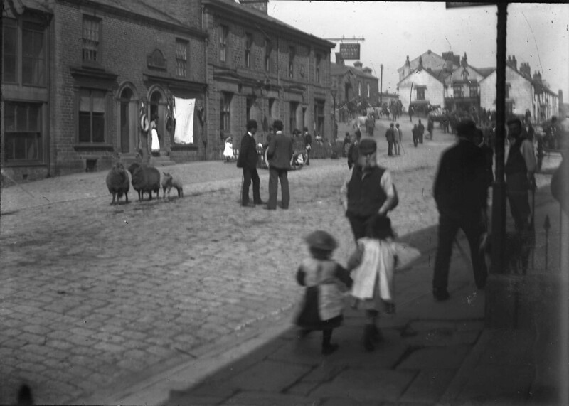
The challenge is to identify the man not the sheep.
Take a close look, most of the men are wearing bowler hats; our man has a flat cap and a huge beard. Now that should be a good clue.
And by the way it is not David Mellor Chairman of our inept planning committee although he does resemble our man in the photo.
R. S-S
|
|
|
|
|
|
Rank: Advanced Member
Groups: Member
Joined: 19/03/2009(UTC)
Posts: 1,494
Was thanked: 2 time(s) in 2 post(s)
|
Copy of photo again as page has turned over.
R. S-S
|
|
|
|
|
|
Rank: Advanced Member
Groups: Member
Joined: 19/03/2009(UTC)
Posts: 1,494
Was thanked: 2 time(s) in 2 post(s)
|
I know for sure that Lady Madonna knows who our man in the photo resembles. He used to be a Carnival organiser; maybe he still is. He was landlord of a Whaley Pub and you often see him driving through Whaley on a tractor.
R. S-S Edited by moderator 18 December 2012 13:10:39(UTC)
| Reason: Not specified
|
|
|
|
|
|
Rank: Advanced Member
Groups: Administration, Member
Joined: 08/05/2011(UTC)
Posts: 352
Location: Whaley Bridge
Thanks: 4 times
Was thanked: 20 time(s) in 13 post(s)
|
|
Jon Goldfinch - Forum Administrator and Town Councillor
Whaley Bridge Town Council - Fernilee Ward
cllr.jong.wbtc@googlemail.com |
|
|
|
|
|
Rank: Advanced Member
Groups: Member
Joined: 19/03/2009(UTC)
Posts: 1,494
Was thanked: 2 time(s) in 2 post(s)
|
If anyone is interested the man in the photo bears an uncanny resemblance to a certain Mr Peter Hodgson from Rookery Farm, Cadster.
R. S-S
|
|
|
|
|
|
Rank: Advanced Member
Groups: Member
Joined: 19/03/2009(UTC)
Posts: 1,494
Was thanked: 2 time(s) in 2 post(s)
|
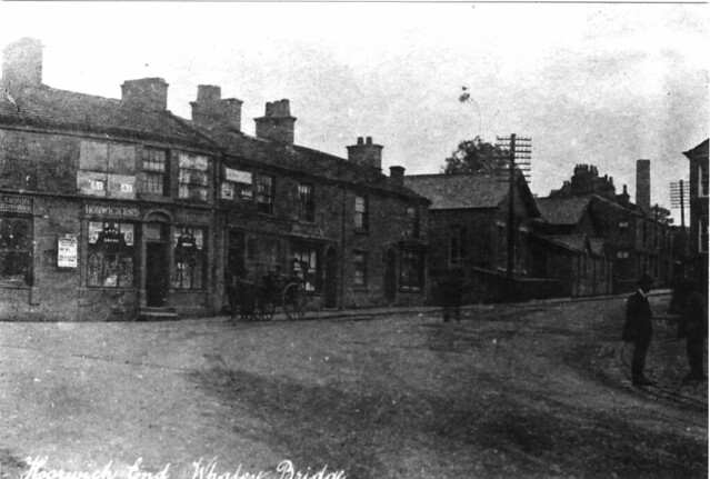
Now this really is a strange photograph and I will probably need the help of Shallcross and possibly RockBanker. This has puzzled me for many years.
It is a very old photo of Horwich End and is before the traffic lights quite obviously but what puzzles me is the industrial chimney and its position.
I'm sure it can't be the Botany chimney even though Long Hill does bear towards the left as you travel up and then a sharp right and Botany chimney was down in the bottom. But it can never have been that tall at that point.
It looks like it is a long way off Shallcross Hall Pit (Brickbarn Pit) and that too could not possibly have beeen that high. So my only guess is that Botany had another boiler house with another chimney before the one that was demolished a few years ago.
I have mentioned on here some time ago that when I did some consultancy work for Edward Hall Limited we did find the remains of an old plant just at the side of Long Hill and perhaps it had something to do with those old workings.
I think the old bale chute from Long Hill into the factory is still there and is quite close to those same old workings. I'll try to get a photo of the bale chute next time I'm passing but in the meantime are there any any suggestions from anyone with regards to the mystery chimney?
R. S-S
|
|
|
|
|
|
Rank: Advanced Member
Groups: Member
Joined: 10/07/2009(UTC) Posts: 794  Location: furness vale Thanks: 3 times
|
Brightening the image brings out a bit more detail. The resolution is low so I can't do any better than this. parabuild attached the following image(s):
|
|
|
|
|
|
 Rank: Advanced Member
Groups: Administration, Member
Joined: 06/09/2010(UTC)
Posts: 94
Location: Around and about
Thanks: 4 times
Was thanked: 5 time(s) in 5 post(s)
|
In my opinion the chimney is that of Shallcross Hall Colliery (Brickbarn Pit). It lines up very nicely when you compare the photo with the 1921 1:2,500 OS map.
|
|
|
|
|
|
 Rank: Advanced Member
Groups: Member
Joined: 23/01/2010(UTC)
Posts: 198
|
Hi all
Google earth ruler in yellow shows approximate angle from outside the White Horse and through the house next to what now is a Nursery on Buxton Road. The site of the pit is marked and is now a recreation area on Mevril Road.
It would be easy to find the exact spot on the ground that the picture was taken, take a compass bearing on the chimney using the houses as a reference-then plot it on an OS map, after subtracting magnetic variation.
Cheers Edited by user 29 December 2012 00:04:17(UTC)
| Reason: Not specified BarryRudd attached the following image(s): |
sometimes over the hill - but never far away. |
|
|
|
|
|
Rank: Advanced Member
Groups: Administration, Member
Joined: 06/09/2010(UTC)
Posts: 94
Location: Around and about
Thanks: 4 times
Was thanked: 5 time(s) in 5 post(s)
|
I shall have another look at this conundrum later today. :)
|
|
|
|
|
|
Rank: Advanced Member
Groups: Member
Joined: 16/06/2009(UTC)
Posts: 559
Was thanked: 3 time(s) in 3 post(s)
|
Good morning.
Fantastic photo R. S-S showing our beloved Horwich End.
Barry's Google map is a great help in solving this puzzle but I think he is slightly out with the starting point (red dot) outside the White Horse.
To me, it appears the photo was taken next to the White Horse from Lower Macclesfield Road and not outside the current Cloud Wine shop where Barry's red dot is.
If I am correct with the photo being taken from Lower Macclesfield Road and you use this point to match up with the house next to the current Toddbrook Nursery School, Barry's yellow line would pass directly through the former location of Shallcross Hall Pit.
No doubt Shallcross will definitely be able to solve the puzzle of Horwich End's mystery chimney.
P. S
Good to see you back R.S-S. You have been greatly missed and I hope you are now back to full fitness.
|
|
|
|
|
|
Rank: Advanced Member
Groups: Administration, Member
Joined: 06/09/2010(UTC)
Posts: 94
Location: Around and about
Thanks: 4 times
Was thanked: 5 time(s) in 5 post(s)
|
OK. Having looked more carefully at the maps I have to admit that Barry Rudd is correct. The chimney is that of the Botany Bleackworks. The map extract shows the alignment.
tarboat attached the following image(s):
|
|
|
|
|
|
Rank: Advanced Member
Groups: Member
Joined: 19/03/2009(UTC)
Posts: 1,494
Was thanked: 2 time(s) in 2 post(s)
|
Hello Tarboat,
Thanks for that map it does show a chimney other than that of the more recent one
As I said I did some survey works for Edward Hall Limited some years back and one day whilst I was there we found a fox in one of the valleys formed by the roofs of the old buildings. It must have come into the Botany off Long Hill and fell down on to the roof valley. I don't know if it had just come from out of the White Horse as some of the men suggested but they put a ladder down for it and went away; a short time later the fox had made good his escape.
But the Chief Engineer was interested in the situation and came up onto the roof area which was flat.
Although interested in the fox he did notice an area about 8feet x 4 feet raised on the flat roof by two courses of bricks which had a plywood top covered in mineral felt.
What was it? Nobody had any idea so we took the top off and looked down into the darkness; as usual nobody had a torch. So we used the tried and trusted methods used in all good adventure films: we dropped a brick down and waited for the results.
It didn't splash so we were on firm ground but we estimated it might be as much as 40 feet to the ground. About the height of two houses. As nobody was prepared to go down on a Botany fashioned rope ladder or harness the Chief Engineer decided it would be best to cast a concrete slab over the hole so that no one could get in. This was done the following day.
But Botany decided that the place should be investigated and one of the older employees (dead now) said there was an old door on the other side of the river that allowed you entrance into the old workings.
I can't for the life of me think just how we got accross the river but we did and when we went in there was most certainly and old deserted factory in there. Most of the floor was chequer plated and the old Kier stages were there. So before any of the plant that so many of us remember there were operations adjacent to Buxton Road.
I think you have cleared up an old mystery for me Tarboat so thank you for that and I must say I like your description of the plant as Botany Bleackworks. A lot of the men thought it was bleak in there particulary in the winter but I have never heard it called the Bleackworks until this morning. A good name I think.
Another interesting item on Tarboat's map is the gasometer near to the chimney.
Gas in Whaley Bridge is another topic that may appear on here soon.
R. S-S
Many thanks for your kind wishes HE.
|
|
|
|
|
|
Rank: Advanced Member
Groups: Member
Joined: 23/01/2010(UTC)
Posts: 198
|
This photo was taken from outside the old bank opposite Cloud Wine.
A bearing on the chimney's estimated location was 192 degrees and the plotted line on Google Earth using the bearing produced the same outcome
Cheers
PS I recently located the foundations of a possible Roman Villa using Google earth after remembering my fathers story of finding some samian ware in a trench dug across his school field to stop Germans landing on it in WW2. Edited by user 29 December 2012 15:41:13(UTC)
| Reason: Not specified BarryRudd attached the following image(s): |
sometimes over the hill - but never far away. |
|
|
|
|
|
Rank: Advanced Member
Groups: Member
Joined: 19/01/2010(UTC) Posts: 821  Thanks: 1 times
Was thanked: 3 time(s) in 3 post(s)
|
Thank you David and Barry. Tried to line up both side by side for comparison.
Norm

Norm attached the following image(s):
|
|
|
|
|
|
 Rank: Advanced Member
Groups: Member
Joined: 08/06/2010(UTC)
Posts: 167
Location: Whaley Bridge
Thanks: 1 times
Was thanked: 2 time(s) in 2 post(s)
|
|
Speak your truth quietly and clearly, and listen to others -even to the dull and the ignorant; they too have their story. |
|
|
|
|
|
Rank: Advanced Member
Groups: Member
Joined: 23/01/2010(UTC)
Posts: 198
|
Hi
Don't know if this in an accurate map-found it on an earlier thread -But if a fire mission were to be called (based on its accuracy) on where the yellow pin is I think it might just go down the mine shaft :-)
Cheers Edited by user 29 December 2012 17:31:11(UTC)
| Reason: Not specified BarryRudd attached the following image(s): |
sometimes over the hill - but never far away. |
|
|
|
|
|
Rank: Advanced Member
Groups: Member
Joined: 19/03/2009(UTC)
Posts: 1,494
Was thanked: 2 time(s) in 2 post(s)
|
Ferni wrote:
Shallcross Pit aka Brick Barn was much further up the field and directly below Lomas' farm. Barry has placed the yellow pin in the wrong place. And it's definitely not the one that was down the Botany, or the one on Shallcross Mill road ( the brickworks) - maybe finding other old photos of nearby will shed lig
Well that is certainly news to me.
Shallcross Hall Pit was not just below Lomas' farm. It was exactly where it is shown on Barry Rudd's copy of the ordnance survey map of 1921 that I put on the forum last year.
The incline from the colliery down to the Sidings is still there and I assume used on a regular basis by walkers.
There is no such incline from below Lomas' farm.
There was an air shaft at the side of the lane towards Lomas' farm from Elnor Lane and just before Shallcross Manor. I am told that Ferodo used this air shaft to dispose of waste asbestos before restrictions were imposed.
Look closely at the first Botany chimney position in 1921: it is adjacent to Long Hill road.
R. S-S
|
|
|
|
|
|
Rank: Advanced Member
Groups: Member
Joined: 08/06/2010(UTC)
Posts: 167
Location: Whaley Bridge
Thanks: 1 times
Was thanked: 2 time(s) in 2 post(s)
|
|
Speak your truth quietly and clearly, and listen to others -even to the dull and the ignorant; they too have their story. |
|
|
|
|
|
Rank: Advanced Member
Groups: Member
Joined: 23/01/2010(UTC)
Posts: 198
|
There does seem to be some discrepancy between the two maps. Ferni's map shows the colliery as being near the hall and nothing on the lower site-was a new site opened there at a later date?
Regardless, the bearing of the two potential locations of the pits is the same 110 degrees from the old bank. The bearing for the chimney is 192 degrees and places it at Botany.
Cheers Edited by user 30 December 2012 11:37:00(UTC)
| Reason: Not specified |
sometimes over the hill - but never far away. |
|
|
|
|
|
You cannot post new topics in this forum.
You cannot reply to topics in this forum.
You cannot delete your posts in this forum.
You cannot edit your posts in this forum.
You cannot create polls in this forum.
You cannot vote in polls in this forum.
