 Rank: Advanced Member
Groups: Member
Joined: 05/04/2009(UTC)
Posts: 363
|
Hello again
Apologies for returning to a previous subject but I have a few questions and observations.
I have said before that I was amazed how many people lived in the small cottages in Bridge Street. Someone pointed out that the cottages opposite the Vets were built in 1913.
When looking at the census returns for 1881 I have relatives in a house on Bridge Street and, on the night of the census, in the house were - husband and wife, 4 kids, 1 grandchild, 1 visitor and 2 boarders (goodness knows where they slept !). There were five households in Bridge Street and also the Goyt Inn.
In 1871 there are 5 households and a "James Johnson - Joiner and Beerhouse Keeper" - but the beerhouse isn't named (could it be the beginnings of the Goyt ?).
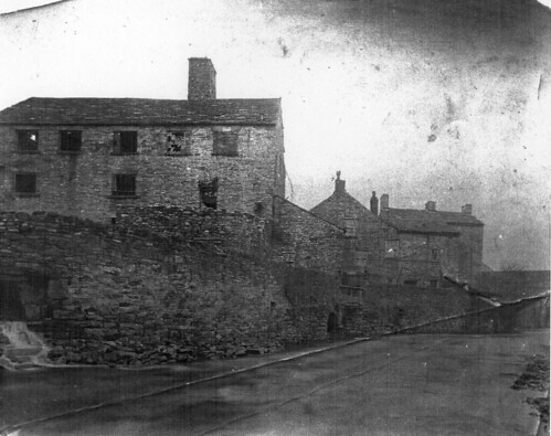
I was wondering therefore when the old photograph of Bridge Street (posting above) is thought to have been taken and was the building prior to 1913 part of the old corn mill?
Just one other point - on the 1871 census there is mention of "Canal Road" which seems to have quite a lot of dwellngs. It follows Market Street on the list with four dwellings, then shows five households on Canal Street, followed by another nine households on Canal Road again. This could be a mistranscription but is there or was there a Canal Road?
Just another little history point to chew over ! 
Gnats
Edited by user 18 August 2009 13:05:45(UTC)
| Reason: Not specified
|
|
|
|
|
|
 Rank: Advanced Member
Groups: Member
Joined: 19/03/2009(UTC)
Posts: 1,494
Was thanked: 2 time(s) in 2 post(s)
|
Hello Gnats,
Read post 18 on this thread: the beerhouse was possibly The Old Tankard.
R. S-S
|
|
|
|
|
|
Rank: Advanced Member
Groups: Member
Joined: 10/09/2009(UTC)
Posts: 97
Was thanked: 1 time(s) in 1 post(s)
|
Thanks for all the photos everyone.
Sorry if someone explained this already, but is the 2nd picture (the corn mill and water wheel) taken from somewhere round where the doctors' surgery is now, so the vet's would be to the left and the Goyt (pub) to the right? Or is it the other way round?
Is it the building that used to be a factory shop at one time? (And before that I think it was used by the Jehovah's witnesses).
Another question, about the "goat" by the Railway. I'd always thought it was a canal feeder coming from Toddbrook Reservoir to the basin. But, if I understood Mr Stephenson-Smythe correctly, the water drove the wheel of the corn mill and then discharged into the Goyt (river). Am I thinking about the wrong goat?
|
|
|
|
|
|
Rank: Advanced Member
Groups: Member
Joined: 06/05/2009(UTC)
Posts: 70
Location: whaleybridge
|
|
|
|
|
|
|
Rank: Advanced Member
Groups: Member
Joined: 10/09/2009(UTC)
Posts: 97
Was thanked: 1 time(s) in 1 post(s)
|
Further to the above I think I finally worked out the location of the corn mill, thanks to a nice picture on the Uniting Church web site
http://www.whaleybridgeunitingpartnership.org.uk/html/sunday_school.htm
(You have to scroll down a bit to see it)
Apologies if the picture has already been posted somewhere else on the forum. It's difficult to keep up with all the threads, but thanks to all who have contributed so much interesting information.
|
|
|
|
|
|
Rank: Advanced Member
Groups: Member
Joined: 05/05/2009(UTC)
Posts: 314
Was thanked: 2 time(s) in 2 post(s)
|
Hi Snowy
Another picture showing the old corn mill,my guess is that it was taken from the site of the car by the fire station looking downstream. the bridge nearer bridge is the old bridge on Bridge Street.
Gnats it shows the bottom house on the right of Bridge street fromthe rear.
george
|
|
|
|
|
|
Rank: Advanced Member
Groups: Member
Joined: 05/05/2009(UTC)
Posts: 314
Was thanked: 2 time(s) in 2 post(s)
|
|
|
|
|
|
|
Rank: Advanced Member
Groups: Member
Joined: 05/05/2009(UTC)
Posts: 314
Was thanked: 2 time(s) in 2 post(s)
|
If at first you don't suceed give up! Or go for a cuppa.
george
|
|
|
|
|
|
Rank: Advanced Member
Groups: Member
Joined: 05/05/2009(UTC)
Posts: 314
Was thanked: 2 time(s) in 2 post(s)
|
I'll try again to post the drawing of the old corn mill.
|
|
|
|
|
|
 Rank: Advanced Member
Groups: Administration, Member
Joined: 23/02/2009(UTC)
Posts: 454
|
Hi George,
That is fantastic. I've included R.S.S's original picture of the corn mill in this post so people can compare. Your drawing appears to predate R.S.S's picture, as there are some stone steps on the right which have gone in R.S.S's picture.
Interesting to see where the water came out into the Goyt as well. I'll have a wander down to see if I can still see the openings shown in the picture.
Cheers
Jon. CllrJonG attached the following image(s): |
Jon Goldfinch - Forum Administrator and Town Councillor
Whaley Bridge Town Council - Fernilee Ward
cllr.jong.wbtc@googlemail.com |
|
|
|
|
|
Rank: *Banned*
Groups: Guest
Joined: 22/02/2009(UTC)
Posts: 1,461
|
R. Stephenson-Smythe wrote:
Hello everyone,
I am very pleased to see the positive response to the photos that JonG has put on here for me. I honestly thought there would be little interest.
I sent the three photos originally to our Town Clerk to highlight some parts of Whaley I had been discussing with her and she asked if JonG could put them on this forum. Certainly no problem for me.
We were discussing the corn mill on Bridge Street and how the Victorians devised a system to get power using the river.
They took the water from out of the Park via a sluice gate and it travelled along a ‘goat’ to turn the water wheel and then the river water simply cascaded back into the river. Brilliant.
The first photo shows the goat at the side of the Railway Pub and was in those days a stone wall. It is now iron railings.
The second photo shows the back of the corn mill and the ‘undershot’ water wheel.
The third photo is simply Bridge Street as it was in the days of the corn mill.
I’ll give you some more information on the corn mill at a later date.
Another interesting feature of the first photo is that when you look down Reservoir Road you can not turn up Whaley Lane. That’s because it did not exist. There were some cottages built there which were demolished at a later date so that Whaley Lane could turn down and go under the pictured bridge. At the time this photo was taken you came down Whaley Lane and went across the level crossing and down the Jodrell/Station approach to get into Whaley.
Hence, even today when you turn off Market Street you do not go on to Whaley Lane but Reservoir Road and as you drive the thirty or so yards when you actually turn right on to Whaley Lane and the traffic coming down Reservoir Road has to give way.
I can not off hand think of another situation where traffic travelling on a straight road has to give way to traffic turning right in front of it.
I will send JonG photos of the excavation works to complete the bottom section of the Lane as soon as I have time. Certainly next week.
Hope that makes things clearer for everyone.
R. S-S
Dear RSS,
It is always good to see what you post on this web site, and indeed a pleasure to read.
I have been reading a lot about the Corn Mill, as it is one of my interests having published a book on Water Mills many years ago.
In your article you mention that the Water Wheel was "undershot".
Having looked at the picture am I right in thinking that the feed from the Mill Race, is fed from the left hand side, and by looking at the picture it looks as if the weel is Breast Shot.
Do we know if the Mill had French bur Stones, and if so how many.
Back in the 19th century their was a famous stone mason who used to travel all over the country called George Norris.
I have a picture of him showing him re cutting a mill stone.
I look forward to hearing from you RSS and hope one day to have the chance to meet you.
Enjoy the rest of the day !
|
|
|
|
|
|
Rank: Advanced Member
Groups: Member
Joined: 10/09/2009(UTC)
Posts: 97
Was thanked: 1 time(s) in 1 post(s)
|

Here's the picture from the Uniting Church site.
It looks like it's the one that George's drawing is based on
|
|
|
|
|
|
Rank: Advanced Member
Groups: Member
Joined: 17/08/2009(UTC)
Posts: 694
Location: Whaley Bridge at heart
|
Not wanting to be picky but, the road from Market Street to the Bridge is called Station Road, then it splits into Reservoir Road and Whaley Lane. I have it on an official o/s map. When the local council erected the new Reservoir Road sign on the railings near the old phone box I thought I would tell someone but never did.
|
|
|
|
|
|
Rank: Advanced Member
Groups: Member
Joined: 19/03/2009(UTC)
Posts: 1,494
Was thanked: 2 time(s) in 2 post(s)
|
Good afternoon JonG,
Good to debate and discuss an important historical topic without some of the recent ramblings that have reappeared.
I think George, bless him, has made his sketch based on the photo below.
R. S-S
|
|
|
|
|
|
Rank: Advanced Member
Groups: Member
Joined: 19/03/2009(UTC)
Posts: 1,494
Was thanked: 2 time(s) in 2 post(s)
|
G. Jackson wrote:
Not wanting to be picky but, the road from Market Street to the Bridge is called Station Road, then it splits into Reservoir Road and Whaley Lane. I have it on an official o/s map. When the local council erected the new Reservoir Road sign on the railings near the old phone box I thought I would tell someone but never did.
Hmm,
Not too sure about that one.
If you look at the very first post on this topic by JonG you will see the first photo shows a view down Reservoir Road. There is nothing at all to indicate why this road would start off under one name and then a few yards further on change its name for no apparent reason.
The first bit of the road can in no way be described as a road that goes anywhere near the station. That is in the sense that Buxton Road goes to Buxton and Chapel Road goes to Chapel.
Whaley Lane eventually joined Reservoir Road but took over the ‘right of way’ for traffic. Whaley lane previously went across the level crossing and to the front of the Jodrell.
The piece of ground from the Jodrell which joins almost at the junction of Market Street and Reservoir Road was known both as The Station Approach and The Jodrell Approach.
This piece of ‘road’ in fact forms a T junction with Reservoir Road.
You may have a very valuable misprinted map in your possession. I suggest you nip over to Bollington and get it valued by Mr David Dickenson.
R. S-S
|
|
|
|
|
|
Rank: Advanced Member
Groups: Member
Joined: 28/09/2009(UTC) Posts: 344  Location: Bugsworth Thanks: 3 times
Was thanked: 3 time(s) in 3 post(s)
|
In the foreground of the very interesting photo posted by Mr Stephenson-Smythe is a leat or culvert discharging into the Goyt. It seems to be too far upstream to be the tailrace from the corn mill wheel, and there appears to be another opening into the Goyt more where I'd expect it to be. So, the question is - where does the water seen issuing from the immediate foreground goat/leat/culvert come from?
|
Buggyite
I am a yellow factioner! |
|
|
|
|
|
Rank: Advanced Member
Groups: Administration, Member
Joined: 23/02/2009(UTC)
Posts: 454
|
The other thing is the proximity of the cornmill to the river. I had thought it was further up Canal street opposite the goyt., but clearly not.
Cheers
Jon. |
Jon Goldfinch - Forum Administrator and Town Councillor
Whaley Bridge Town Council - Fernilee Ward
cllr.jong.wbtc@googlemail.com |
|
|
|
|
|
Rank: Advanced Member
Groups: Member
Joined: 17/08/2009(UTC)
Posts: 694
Location: Whaley Bridge at heart
|
My Dear R. S-S., Thanks, but if you look on the new map posted today under "Historic map of WB" you will clearly see that Reservoir Road didn't go under the bridge ( as it wasn't there ) but joined Whaley Lane at the west side of the railway crossing point. The road to which I refer as being Station Road would have led to the station and then crossing the tracks to join the junction of Reservoir Rd.and W. Lane. David Dickenson indeed !!!!!!
|
|
|
|
|
|
Rank: Advanced Member
Groups: Member
Joined: 10/07/2009(UTC) Posts: 794  Location: furness vale Thanks: 3 times
|
The earliest map at 1 : 10560 scale which I can find on line is dated 1881. It appears that the level crossing was still in use at this date. The station end of Reservoir Road is shown as "Springbank". The 1899 map shows the road layout as we now know it.
parabuild attached the following image(s):
|
|
|
|
|
|
Rank: Advanced Member
Groups: Member
Joined: 28/09/2009(UTC) Posts: 344  Location: Bugsworth Thanks: 3 times
Was thanked: 3 time(s) in 3 post(s)
|
it looks to me like Whaley Lane crosses the railway at the level crossing, whereas Reservoir Road (Springbank) goes under the railway bridge as at present.
I'd always assumed that the level crossing would have been removed when the extension of the line to Buxton was opened in 1863, but this dates the removal later than that. |
Buggyite
I am a yellow factioner! |
|
|
|
|
|
You cannot post new topics in this forum.
You cannot reply to topics in this forum.
You cannot delete your posts in this forum.
You cannot edit your posts in this forum.
You cannot create polls in this forum.
You cannot vote in polls in this forum.
